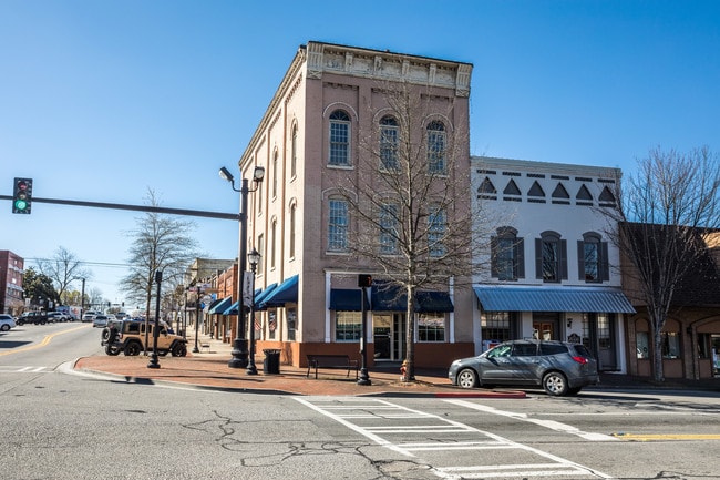
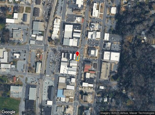
Property Record
101 N Wall St, Calhoun, GA 30701

NEARBY LISTINGS FOR SALE OR LEASE
Property Detail
101 N Wall St
C25-132
First Sec
Storebuilding
52X70X52
X
Gordon
13213C0275D
Georgia
2024
0.04 AC
2024
Georgia Northwest
970500
Other Market Areas
5,460 SF
Calhoun, GA
DEMOGRAPHICS near 101 N Wall St
1 Mile
3 Mile
5 Mile
2024 Total Population
4,964
25,192
34,200
2029 Population
5,360
27,003
36,630
Pop Growth 2024-2029
+ 7.98%
+ 7.19%
+ 7.11%
Average Age
37
38
39
2024 Total Households
1,889
9,391
12,626
HH Growth 2024-2029
+ 7.83%
+ 6.97%
+ 6.91%
Median Household Inc
$47,533
$42,511
$47,436
Avg Household Size
2.50
2.60
2.60
2024 Avg HH Vehicles
2.00
2.00
2.00
Median Home Value
$221,705
$173,308
$179,982
Median Year Built
1977
1985
1986
Nearby Places
Map Layers
Map Styles
 Street
 Aerial
- Restaurants
- Banks
- Shops
- Fitness
- Groceries
SALE & LEASE HISTORY
LISTING DATE
SALE/LEASE

Sep 29, 2017
For Sale
Oct 30, 2017
For Sale
Feb 08, 2018
For Lease
Nearby Properties
Address
Land Use
TOTAL SIZE
Lot Size
Zoning
Address
Land Use
TOTAL SIZE
Lot Size
Zoning
5,040 SF
13.39 AC
C-2
Address
Land Use
TOTAL SIZE
Lot Size
Zoning
215,296 SF
19.94 AC
R-2
Address
Land Use
TOTAL SIZE
Lot Size
Zoning
209,387 SF
42.22 AC
R-1
Address
Land Use
TOTAL SIZE
Lot Size
Zoning
18,640 SF
75.10 AC
C-2
Address
Land Use
TOTAL SIZE
Lot Size
Zoning
192,578 SF
25.47 AC
C-N
Address
Land Use
TOTAL SIZE
Lot Size
Zoning
197,500 SF
14.55 AC
IND-G
Address
Land Use
TOTAL SIZE
Lot Size
Zoning
85,560 SF
3 AC
C-2
Address
Land Use
TOTAL SIZE
Lot Size
Zoning
4,318 SF
19.26 AC
IND-G
Address
Land Use
TOTAL SIZE
Lot Size
Zoning
26,922 SF
19.71 AC
C-4
Address
Land Use
TOTAL SIZE
Lot Size
Zoning
554,897 SF
42.41 AC
IND-G
Address
Land Use
TOTAL SIZE
Lot Size
Zoning
88,000 SF
8.87 AC
IND-G
Address
Land Use
TOTAL SIZE
Lot Size
Zoning
806,290 SF
74.96 AC
IND-G
Address
Land Use
TOTAL SIZE
Lot Size
Zoning
28,481 SF
24.41 AC
R-1B
Address
Land Use
TOTAL SIZE
Lot Size
Zoning
6,956 SF
7 AC
R-2
Address
Land Use
TOTAL SIZE
Lot Size
Zoning
96,533 SF
3.53 AC
R-2
Address
Land Use
TOTAL SIZE
Lot Size
Zoning
4,357 SF
34.97 AC
R-2
Address
Land Use
TOTAL SIZE
Lot Size
Zoning
63,612 SF
8.67 AC
I1
Address
Land Use
TOTAL SIZE
Lot Size
Zoning
73,792 SF
5.38 AC
C-2
Address
Land Use
TOTAL SIZE
Lot Size
Zoning
17,685 SF
25.67 AC
C-2
Address
Land Use
TOTAL SIZE
Lot Size
Zoning
51.30 AC
IND-G
Address
Land Use
TOTAL SIZE
Lot Size
Zoning
16,274 SF
12.25 AC
CU
Address
Land Use
TOTAL SIZE
Lot Size
Zoning
32,360 SF
7.40 AC
IND-G
Address
Land Use
TOTAL SIZE
Lot Size
Zoning
214,593 SF
11.21 AC
IND-G
Address
Land Use
TOTAL SIZE
Lot Size
Zoning
20,072 SF
66.16 AC
A-1
Address
Land Use
TOTAL SIZE
Lot Size
Zoning
11,192 SF
14.97 AC
IND-G
Address
Land Use
TOTAL SIZE
Lot Size
Zoning
57,244 SF
10.60 AC
C-2
Address
Land Use
TOTAL SIZE
Lot Size
Zoning
41,333 SF
2.50 AC
C-2
Address
Land Use
TOTAL SIZE
Lot Size
Zoning
188,378 SF
68.91 AC
IND-G
Address
Land Use
TOTAL SIZE
Lot Size
Zoning
213,100 SF
10.96 AC
IND-G
Address
Land Use
TOTAL SIZE
Lot Size
Zoning
26,974 SF
3.47 AC
C-2
The World's #1 Commercial Real Estate Marketplace
Connect with us
© 2026 CoStar Group
The information above has been obtained from sources believed reliable. While we do not doubt its accuracy we have not verified it and make no guarantee, warranty or representation about it. It is your responsibility to independently confirm its accuracy and completeness. Any projections, opinions, assumptions, or estimates used are for example only and do not represent the current or future performance of the property. The value of this transaction to you depends on tax and other factors which should be evaluated by your tax, financial, and legal advisors. You and your advisors should conduct a careful, independent investigation of the property to determine to your satisfaction the suitability of the property for your needs.